Casius quadrangle
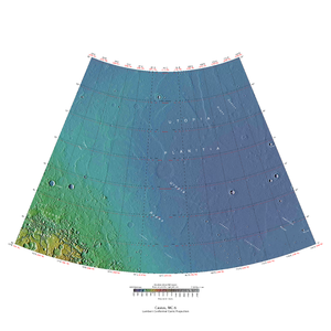
The Casius quadrangle is one of a series of 30 quadrangle maps of Mars used by the United States Geological Survey (USGS) Astrogeology Research Program . The quadrangle is located in the north-central portion of Mars’ eastern hemisphere and covers 60° to 120° east longitude (240° to 300° west longitude) and 30° to 65° north latitude. The quadrangle uses a Lambert conformal conic projection at a nominal scale of 1:5,000,000 (1:5M). The Casius quadrangle is also referred to as MC-6 (Mars Chart-6). [1] Casius quadrangle contains part of Utopia Planitia and a small part of Terra Sabaea . The southern and northern borders of the Casius quadrangle are approximately 3,065 km and 1,500 km wide, respectively. The north to south distance is about 2,050 km (slightly less than the length of Greenland). [2] The quadrangle covers an approximate area of 4.9 million square km, or a little over 3% of Mars’ surface area. [3]
Page Revisions
| Year | Metadata | Sections | Top Words | First Paragraph |
| 2018 |
245992 characters 26 sections 156 paragraphs 141 images 292 internal links 29 external links |
hiwish 0.571 hirise 0.405 program 0.304 scalloped 0.169 view 0.158 casius 0.158 layers 0.148 polygons 0.134 ice 0.125 pedestal 0.125 ridges 0.124 crater 0.114 close 0.110 image 0.103 pits 0.090 |
The Casius quadrangle is one of a series of 30 quadrangle maps of Mars used by the United States Geological Survey (USGS) Astrogeology Research Program . The quadrangle is located in the north-central portion of Mars’ eastern hemisphere and covers 60° to 120° east longitude (240° to 300° west longitude) and 30° to 65° north latitude. The quadrangle uses a Lambert conformal conic projection at a nominal scale of 1:5,000,000 (1:5M). The Casius quadrangle is also referred to as MC-6 (Mars Chart-6). [1] Casius quadrangle contains part of Utopia Planitia and a small part of Terra Sabaea . The southern and northern borders of the Casius quadrangle are approximately 3,065 km and 1,500 km wide, respectively. The north to south distance is about 2,050 km (slightly less than the length of Greenland). [2] The quadrangle covers an approximate area of 4.9 million square km, or a little over 3% of Mars’ surface area. [3] |
|
| 2017 |
226295 characters 25 sections 131 paragraphs 118 images 294 internal links 29 external links |
hiwish 0.539 hirise 0.390 program 0.288 scalloped 0.191 casius 0.189 ice 0.139 ridges 0.136 polygons 0.130 pedestal 0.127 view 0.126 crater 0.126 image 0.116 nilosyrtis 0.105 close 0.096 craters 0.094 |
The Casius quadrangle is one of a series of 30 quadrangle maps of Mars used by the United States Geological Survey (USGS) Astrogeology Research Program . The quadrangle is located in the north central portion of Mars’ eastern hemisphere and covers 60° to 120° east longitude (240° to 300° west longitude) and 30° to 65° north latitude. The quadrangle uses a Lambert conformal conic projection at a nominal scale of 1:5,000,000 (1:5M). The Casius quadrangle is also referred to as MC-6 (Mars Chart-6). [1] Casius quadrangle contains part of Utopia Planitia and a small part of Terra Sabaea . The southern and northern borders of the Casius quadrangle are approximately 3,065 km and 1,500 km wide, respectively. The north to south distance is about 2,050 km (slightly less than the length of Greenland). [2] The quadrangle covers an approximate area of 4.9 million square km, or a little over 3% of Mars’ surface area. [3] |
|
| 2016 |
191419 characters 25 sections 100 paragraphs 89 images 283 internal links 20 external links |
hiwish 0.481 hirise 0.364 program 0.259 casius 0.250 ice 0.176 scalloped 0.164 polygons 0.145 nilosyrtis 0.139 crater 0.134 baldet 0.120 ridges 0.120 image 0.119 layers 0.108 concentric 0.107 mold 0.106 |
The Casius quadrangle is one of a series of 30 quadrangle maps of Mars used by the United States Geological Survey (USGS) Astrogeology Research Program . The quadrangle is located in the north central portion of Mars’ eastern hemisphere and covers 60° to 120° east longitude (240° to 300° west longitude) and 30° to 65° north latitude. The quadrangle uses a Lambert conformal conic projection at a nominal scale of 1:5,000,000 (1:5M). The Casius quadrangle is also referred to as MC-6 (Mars Chart-6). [1] Casius quadrangle contains part of Utopia Planitia and a small part of Terra Sabaea . The southern and northern borders of the Casius quadrangle are approximately 3,065 km and 1,500 km wide, respectively. The north to south distance is about 2,050 km (slightly less than the length of Greenland). [2] The quadrangle covers an approximate area of 4.9 million square km, or a little over 3% of Mars’ surface area. [3] |
|
| 2015 |
134731 characters 15 sections 54 paragraphs 50 images 242 internal links 16 external links |
casius 0.306 hiwish 0.285 hirise 0.266 nilosyrtis 0.227 ice 0.221 baldet 0.197 mold 0.173 crater 0.167 program 0.157 concentric 0.156 fill 0.151 scalloped 0.146 layers 0.137 image 0.136 gullies 0.119 |
The Casius quadrangle is one of a series of 30 quadrangle maps of Mars used by the United States Geological Survey (USGS) Astrogeology Research Program . The quadrangle is located in the north central portion of Mars’ eastern hemisphere and covers 60° to 120° east longitude (240° to 300° west longitude) and 30° to 65° north latitude. The quadrangle uses a Lambert conformal conic projection at a nominal scale of 1:5,000,000 (1:5M). The Casius quadrangle is also referred to as MC-6 (Mars Chart-6). [1] Casius quadrangle contains part of Utopia Planitia and a small part of Terra Sabaea . The southern and northern borders of the Casius quadrangle are approximately 3,065 km and 1,500 km wide, respectively. The north to south distance is about 2,050 km (slightly less than the length of Greenland). [2] The quadrangle covers an approximate area of 4.9 million square km, or a little over 3% of Mars’ surface area. [3] |
|
| 2014 |
109113 characters 10 sections 36 paragraphs 34 images 231 internal links 11 external links |
nilosyrtis 0.319 casius 0.287 ice 0.269 hirise 0.250 mold 0.244 concentric 0.219 fill 0.213 hiwish 0.210 ring 0.150 tilt 0.149 cracks 0.140 program 0.121 crater 0.117 layers 0.110 image 0.101 |
The Casius quadrangle is one of a series of 30 quadrangle maps of Mars used by the United States Geological Survey (USGS) Astrogeology Research Program . The quadrangle is located in the north central portion of Mars’ eastern hemisphere and covers 60° to 120° east longitude (240° to 300° west longitude) and 30° to 65° north latitude. The quadrangle uses a Lambert conformal conic projection at a nominal scale of 1:5,000,000 (1:5M). The Casius quadrangle is also referred to as MC-6 (Mars Chart-6). [1] The southern and northern borders of the Casius quadrangle are approximately 3,065 km and 1,500 km wide, respectively. The north to south distance is about 2,050 km (slightly less than the length of Greenland). [2] The quadrangle covers an approximate area of 4.9 million square km, or a little over 3% of Mars’ surface area. [3] |
|
| 2013 |
108294 characters 10 sections 36 paragraphs 33 images 231 internal links 11 external links |
nilosyrtis 0.319 casius 0.287 ice 0.269 hirise 0.250 mold 0.244 concentric 0.219 fill 0.213 hiwish 0.210 ring 0.150 tilt 0.149 cracks 0.140 program 0.121 crater 0.117 layers 0.110 image 0.101 |
The Casius quadrangle is one of a series of 30 quadrangle maps of Mars used by the United States Geological Survey (USGS) Astrogeology Research Program . The quadrangle is located in the north central portion of Mars’ eastern hemisphere and covers 60° to 120° east longitude (240° to 300° west longitude) and 30° to 65° north latitude. The quadrangle uses a Lambert conformal conic projection at a nominal scale of 1:5,000,000 (1:5M). The Casius quadrangle is also referred to as MC-6 (Mars Chart-6). [1] The southern and northern borders of the Casius quadrangle are approximately 3,065 km and 1,500 km wide, respectively. The north to south distance is about 2,050 km (slightly less than the length of Greenland). [2] The quadrangle covers an approximate area of 4.9 million square km, or a little over 3% of Mars’ surface area. [3] |
|
| 2012 |
98877 characters 9 sections 34 paragraphs 30 images 230 internal links 11 external links |
nilosyrtis 0.362 casius 0.285 hirise 0.283 concentric 0.248 fill 0.241 hiwish 0.238 mold 0.184 ice 0.164 cracks 0.158 program 0.137 crater 0.133 layers 0.125 ring 0.122 image 0.114 pits 0.106 |
The Casius quadrangle is one of a series of 30 quadrangle maps of Mars used by the United States Geological Survey (USGS) Astrogeology Research Program . The quadrangle is located in the north central portion of Mars’ eastern hemisphere and covers 60° to 120° east longitude (240° to 300° west longitude) and 30° to 65° north latitude. The quadrangle uses a Lambert conformal conic projection at a nominal scale of 1:5,000,000 (1:5M). The Casius quadrangle is also referred to as MC-6 (Mars Chart-6). [1] |
|
| 2011 |
48303 characters 9 sections 37 paragraphs 24 images 86 internal links 5 external links |
nilosyrtis 0.375 hirise 0.279 casius 0.253 concentric 0.225 hiwish 0.224 fill 0.218 ice 0.170 cracks 0.164 mold 0.143 crater 0.130 image 0.130 program 0.130 scalloped 0.121 layers 0.113 pits 0.110 |
The Casius quadrangle is one of a series of 30 quadrangle maps of Mars used by the United States Geological Survey (USGS) Astrogeology Research Program . The quadrangle is located in the north central portion of Mars’ eastern hemisphere and covers 60° to 120° east longitude (240° to 300° west longitude) and 30° to 65° north latitude. The quadrangle uses a Lambert conformal conic projection at a nominal scale of 1:5,000,000 (1:5M). The Casius quadrangle is also referred to as MC-6 (Mars Chart-6). [1] |
|
| 2010 |
43836 characters 9 sections 31 paragraphs 19 images 86 internal links 5 external links |
nilosyrtis 0.417 casius 0.282 hirise 0.229 concentric 0.215 fill 0.208 ice 0.190 mold 0.159 image 0.145 layers 0.126 hiwish 0.125 patterned 0.118 crater 0.113 ring 0.112 quadrangle 0.109 periglacial 0.108 |
The Casius quadrangle is one of a series of 30 quadrangle maps of Mars used by the United States Geological Survey (USGS) Astrogeology Research Program . The quadrangle is located in the northcentral portion of Mars’ eastern hemisphere and covers 60° to 120° east longitude (240° to 300° west longitude) and 30° to 65° north latitude. The quadrangle uses a Lambert conformal conic projection at a nominal scale of 1:5,000,000 (1:5M). The Casius quadrangle is also referred to as MC-6 (Mars Chart-6). [1] |
|
| 2009 |
28439 characters 5 sections 18 paragraphs 12 images 77 internal links 5 external links |
nilosyrtis 0.435 casius 0.392 patterned 0.165 hirise 0.159 periglacial 0.151 ground 0.127 scalloped 0.125 quadrangle 0.124 utopia 0.121 covers 0.116 polygonal 0.113 adamas 0.112 mile 0.103 astapus 0.101 epithet 0.101 |
The Casius quadrangle is one of a series of 30 quadrangle maps of Mars used by the United States Geological Survey (USGS) Astrogeology Research Program . The quadrangle is located in the northcentral portion of Mars’ eastern hemisphere and covers 60° to 120° east longitude (240° to 300° west longitude) and 30° to 65° north latitude. The quadrangle uses a Lambert conformal conic projection at a nominal scale of 1:5,000,000 (1:5M). The Casius quadrangle is also referred to as MC-6 (Mars Chart-6). [1] |